All photos by author
As the ice continues to shrink, the 2017 sailing season could see a record number of vessels transiting the fabled Canadian Northwest Passage. The first vessel has already left port. An ancient resuscitated icebreaker is on a 23,000-kilometre, 150-day voyage from Toronto to Victoria to help mark Canada’s 150th birthday. A giant cruise ship will make her second passage. A three-masted vessel will be the first tall sailing ship to tackle the passage in more than 100 years. Canadian vessels have a surprisingly long and substantial history of commercial shipping through the CNWP. Regular commercial shipping between European, North American, and Asian ports is widely anticipated.
The onus is now on Canada to assert control of shipping through the Canadian Northwest Passage, with patrol vessels, world-class icebreakers, deep sea ports, and search and rescue facilities.
“An open Northwest Passage means… an international trade route that will have a profound influence on…the patterns of worldwide trade… A year-round sea-route in this area could do what the railroads did for the United States, and might do it quicker.” Dr. Charles F. Jones, President, Humble Oil and Refining Company, U.S. operating subsidiary of Standard Oil of New Jersey (now ExxonMobil), 1969.
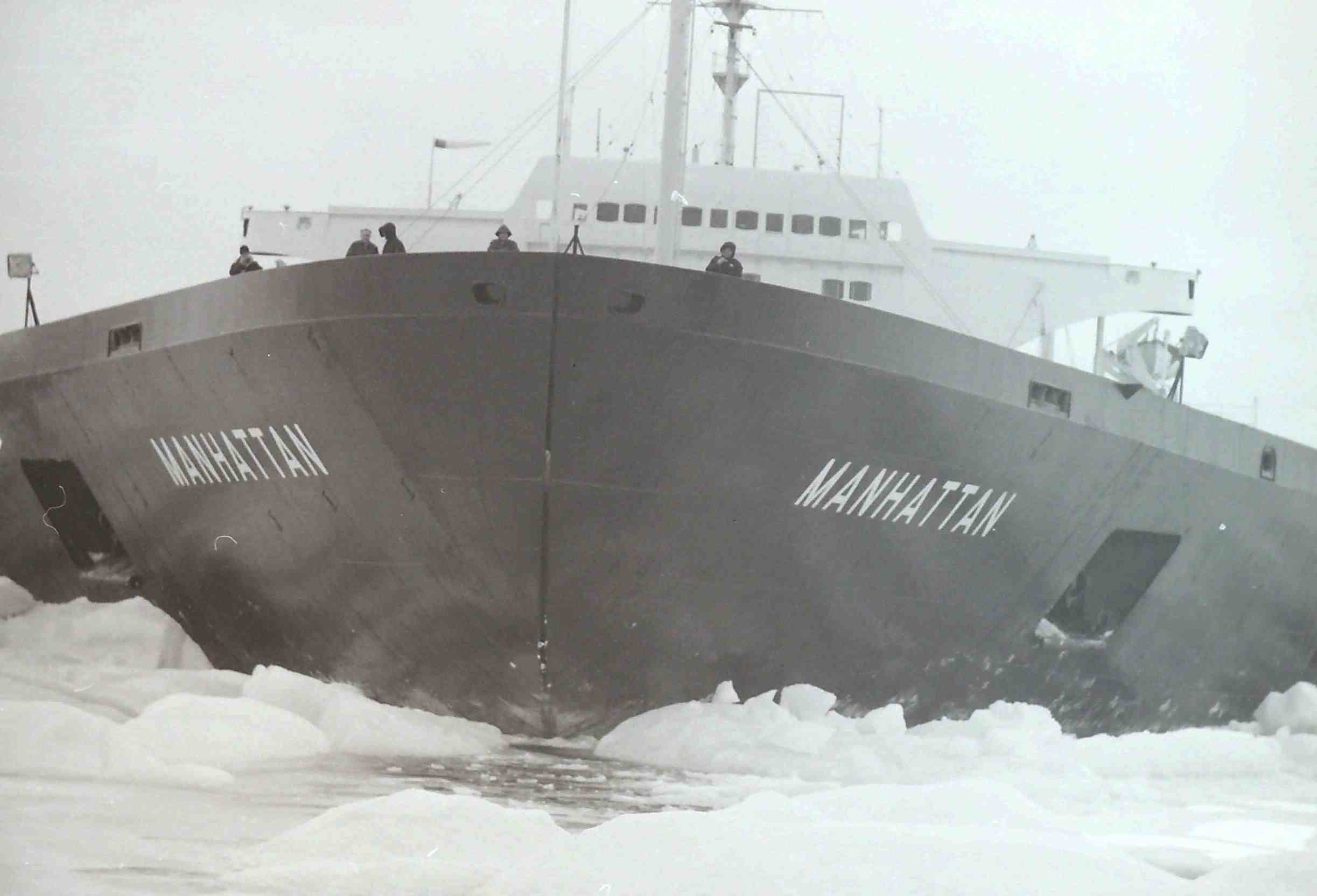
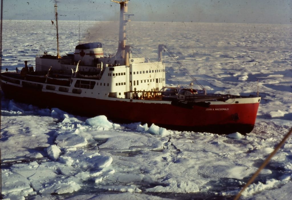
In 1969, the polar ice of the fabled—some said “delusional”— Northwest Passage (NWP), all but defeated Humble’s SS Manhattan icebreaking supertanker in its quest for commercial cargo shipping through the NWP, as it had for 500 years. I know, because I was aboard the Manhattan when it was gripped solid in a vice of ice, unable to move for 34 hours. From what I could see from the bridge of the Manhattan, this precursor of NWP shipping would still be there if the Canadian Coastguard icebreaker John A. Macdonald had not been on hand to free it.
Canada claims the Northwest Passage as “inland water,” subject to its full coastal state control; the United States and the European Union say it’s an international strait, open to vessels from any country that can make it through. Humble did not seek Canada’s permission to sail the passage, but Prime Minister Pierre Trudeau’s government granted permission without being asked. Neither did Humble ask accompanying assistance from the Macdonald, but that, too was made available
And a good thing it was. A U.S. Coastguard icebreaker, assigned to accompany the Manhattan, became stuck at the first challenge of ice, and had to be freed by the Macdonald. Accompanied by another Canadian icebreaker, the U.S. vessel limped home through a less challenging section of the Passage. That left it to the Macdonald to free an ice-bound (“becalmed,” in nautical terms) Manhattan a total of 12 times on the 4,500-mile return voyage from New York to the Prudhoe Bay oil field on the North Slope of Alaska.
That was 1969. Thirty five years later, a mini armada of vessels, from tiny to Titanic-size, pass through the Northwest Passage with no apparent difficulty during a short summer season of about six to eight weeks or so in August and September. The next decades may bring great fleets of commercial ships. That was hardly unexpected.
A viable northwest passage could reduce shipping distances between East Asia, the eastern seaboard of North America, and Europe by thousands of miles, and accommodate many cargo ships too large to pass through the Panama canal. But however large the economic rewards, they will be puny compared to global warming’s already mounting economic and environmental costs, to say nothing of human suffering and loss of life.
The story behind the Manhattan voyage begins with a well drilled on the flat, narrow Arctic coastal plain of Alaska, stretching 380 miles across the northwest corner of the continent. From 1963 to 1967, nine wildcat wells drilled in search of a new oil field on the coastal plain were all dry holes. Drilling started on a 10th wildcat in early 1967. Referring to this latest exploratory hole, the 1967 annual review of the Bulletin of the American Association of Petroleum Geologists predicted “little or no geophysical or geological work will be conducted on the North Slope during 1968 unless the current drilling well is successful.” In January 1968, Prudhoe Bay No. 1 well discovered the largest oil and gas field in North America. The purpose of the Manhattan voyage was to determine the feasibility of shipping Prudhoe Bay oil by tankers to refineries in the eastern United States and in Europe.
As editor of Oilweek, I was one of the journalist aboard the Macdonald for six days, and the Manhattan for two days, on the toughest 900-mile leg of the voyage to Prudhoe Bay. I was aboard the Manhattan when it lay trapped in McClure Strait. I watched from the bridge as the Macdonald, alongside the Manhattan, rammed forward and aft to break the ice and finally release the big tanker.
Following is my account of the voyage, adapted from my published reports in Oilweek, in September and November 1969.
In the middle of a Polynya—a sort of island of water in the middle of an ocean of ice—in the middle of Viscount Melville Sound set the supertanker SS Manhattan, on her trial voyage through the Northwest Passage. Moored alongside the Manhattan in this small patch of Mediterranean blue, and taking on diesel fuel from the tanker, lay the John A. Macdonald.
Parading along the deck of the Manhattan was a stubble-bearded young man, Bill Smith, petroleum writer for the New York Times. He was dressed in a red tartan shirt and a blue beret borrowed from the Canadian Coast Guard, lustily playing the Skye Boat Song on the bagpipes. It was an unofficial tribute from the Manhattan to the Canadian icebreaker and her crew for helping the Manhattan to bust through ice ridges. But the toughest ice challenges were still to come.
Planning for the icebreaker tanker trials began almost immediately after the discovery in January 1968, of North America’s largest oil field at Prudhoe Bay. If economically feasible, tanker shipments might be a preferable alternative to a pipeline across Alaska to the open water of the Pacific Ocean, for the movement of Prudhoe Bay’s five billion barrels of oil [which later turned out to be some 14 billion barrels of oil.]
Humble contracted a pair of Montreal firms, German & Milne, naval architects, and Northern Associates, Arctic environmental and logistics experts, for preliminary feasibility studies. Humble was looking at the possibility of using giant icebreaker tankers for oil shipments not only through the Northwest Passage, but also across the centre of the polar icecap, passing close by the North Pole, to Western Europe and a port such as Rotterdam. The shipping distance would be 4,000 miles, compared with almost 13,000 miles for tanker shipments from the world’s largest oil fields that border the Persian Gulf, in Saudi Arabia, Kuwait, Iran, Iraq.
German and Milne envisioned 250,000-ton icebreaker tankers. “A six-foot sheet of ice may be a formidable barrier to a 10,000-ton ship with 20 feet of draught, but far less of a barrier to a 250,000-ton ship with 70 feet of draught,” it reported. “The difference between the two is something like the difference between a tack hammer and a 16-pound sledge hammer.”
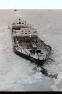
Humble surveyed the world fleet of tankers for its test trials, and selected the 115,000-ton SS Manhattan. With 43,000 shaft horsepower from the steam turbines for the twin propellers, the Manhattan had nearly twice the horsepower of other tankers of comparable size.
The Manhattan was sliced into four sections and spent seven months in four different dry docks. Two shipyards built a new 125-foot bow, designed by the U.S. Coast Guard and the Massachusetts Institute of Technology to increase the ice-breaking capability by a projected 40 to 60 percent. Ice fenders made from 1-1/4-inch steel were added to the hull, extending from behind the bow to the stern. Nine thousand tons of steel was added, boosting the ship’s fully-loaded weight to 151,000 tons with a draught of 54 feet. A vast array of the most sophisticated electronic gear was installed to monitor the ship’s performance under varying ice conditions. Two large Sirkorsky helicopters were aboard to ferry researchers out on the ice to core, sample and analyze ice conditions along the route. Aircraft of the Canadian Department of Transport and the U.S. Coast Guard would fly ice reconnaissance the for Manhattan, employing side scanning radar, infrared photography, and laser beams.
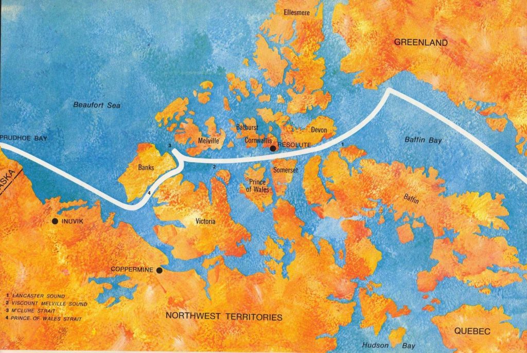
The Manhattan sailed out of Philadelphia on August 24 on her voyage to Prudhoe Bay. Fewer than a dozen crossings had been made through the Northwest Passage, hugging the narrow passes around the southern edge of the Arctic Islands, sheltered from the thickest of the ice, but too shallow for supertankers. No vessel had made the passage through the deeper waters where the ice cover is heavier and thicker, and where the Manhattan would sail.
It was John Cabot who had first set out in search of the Northwest Passage in 1497, five years after Columbus landed on the North American continent. Norwegian explorer Roald Amundsen became the first to sail through the route with his 47-ton herring boat, the Gjoa, in 1903-06, and Sergeant H.A. Larsen in the 80-ton RCMP schooner St. Roch was the first to do it in a single year, 1944.
Big things were hoped for from the Manhattan voyage. “We believe the Manhattan has the power and design that will enable her to bull her way through most ice ridges like an immense ramrod,” Stanley B. Hass, Humble’s project commander, boasted as the ship prepared to sail. Before the voyage was over, he would admit that the Manhattan could not have made it through without the icebreaking assistance of the Macdonald.
On September 5, with a few other news media, I joined the Macdonald at Resolute on Cornwallis Island, for the next leg of the journey, some 900 miles through the heart of the Northwest Passage to Sachs Harbour, near Inuvik and the Mackenzie River delta. It had so far been clear sailing from Philadelphia. The U.S. media aboard the Manhattan had reported encountering only bits of ice, “as big as grand pianos.” From Sachs Harbour to Prudhoe Bay would again be clear sailing through relatively open water. The challenges lay between Resolute and Sachs Harbour.
Beyond Resolute, the Macdonald was leading the convoy, followed by the U.S. Coast Guard icebreaker, the Northwind, through heavy fog and relatively thin and scattered ice. As the ice pack grew heavier, Captain Paul Fournier on the Macdonald radioed back to the Manhattan: “The ice is a little heavier up ahead. We will take up our position astern of you.” It was time to see what the Manhattan could do.
An officer on the bridge of the Macdonald commented, “If we have any trouble it will likely be with the Northwind.” At its best, the Northwind was considered an underpowered icebreaker. Two years earlier, the Macdonald rescued both the Northwind and another U.S. icebreaker, the Staten Island, 500 miles north of Point Barrow where the Northwind was on a supply mission to an ice station. Earlier in the summer, the Northwind had crossed the Northwest Passage west to east to join the Manhattan at Thule, Greenland. One of its six engines was put out of commission by a broken shaft.
The first difficulties
The first difficulties started on the evening of September 8 in Viscount Mellville Sound, when the Northwind became stuck in the ice. Twice the Macdonald freed her by breaking up the ice that held the U.S. icebreaker. The Northwind was forced to abandon the convoy. She returned to Resolute, to make the run to Alaska going south through Coronation Strait, where the ice is thinner, accompanied by the Canadian icebreaker D’Ibverville.
While the convoy was stopped to free the Northwind, the Manhattan hove to. In the morning she was caught in a solid cover of multi-year ice pack some eight to nine feet thick in the flat, and 15 to 20 feet thick in ridges. At a speed of six knots, the Manhattan was intended to break through ice ridges 40 to 50 feet thick. Breaking through from a standing start was another matter. She was unable to back up and run at the ridges, in part because she had only one-third as much power going astern.
The Macdonald was better equipped for the job of ramming through ice ridges. Until the arrival of the larger, more powerful Canadian Coast Guard icebreaker, the St. Laurent, then on its shakedown cruise, the Macdonald was North America’s most powerful icebreaker. At 9,000 tons, the Macdonald has 15,000 horsepower to drive her propellers, with as much power available for going astern as going ahead. This gave her greater ability than the Manhattan to back up and make repeated runs to ram and break ice ridges.
It was up to the Macdonald to steam alongside the Manhattan, break up those ridges, and relieve the pressure that gripped the tanker. It was after that job was done that Bill Smith paraded the deck of the Manhattan playing the Skye Boat Song on the bagpipes in a salute to the flagship of the Canadian Coast Guard. It was just the first of a dozen times that the Macdonald would rescue the big tanker. Another two days brought a new call for help. One of the Manhattan’s Sikorsky S-60 helicopters, providing support for an ice surface party, had partly broken through a patch of thin ice and lay damaged on its side, looking like a dead seagull with its feet sticking up in the air. In a tricky, skillfully executed operation, Captain Fournier managed to maneuver the Macdonald through the ice to within a few feet of the chopper, lowered a work party over the side, and hoisted the chopper onto the deck at the stern. Two hours later, the Macdonald transferred the damaged craft to the deck of the Manhattan and a Very Humble Oil Company.
Challenging McClure Strait
The Manhattan met its severest test, however, in McLure Strait, an almost solid block of ice between the northern end of Banks Island and Melville Island at the western edge of the Northwest Passage. Butting up against the edge of the permanent polar ice pack, McLure Strait is a formidable barrier. No ship had ever managed to sail through this strait. An easier route lay through Prince of Wales Strait, a narrow finger along the east coast of Banks Island and around the southern end of the big island.
There was very likely a political as well as a logistical reason for attempting to navigate McLure Strait, to bolster U.S. insistence that the NWP is an international strait. The route through McLure is wider, more distant from Canada’s Arctic Islands, where the claim of an international strait might be stronger. The route through Prince of Wales Strait lies much closer to Canadian land, where the claim of Canadian inland water would seem stronger.
I was able to observe the tanker’s test of McLure Strait from a unique vantage point. Captain Roger Steward had invited members, of the Canadian press corps on the Macdonald to join the big tanker for a part of the journey. I was the only one who accepted. Was it because the Manhattan was a dry ship while the Macdonald had a bar, albeit open for only a very limited time each day?
From the bridge of the Manhattan, I saw how Captain Steward and his officers handled the test; I heard the conversation between the two ships; and I saw from a different perspective the manner in which the Macdonald freed the tanker when she was caught in a polar grip.
For 34 hours, the Manhattan and the Macdonald were beset in a polar ice flow. The position was directly on the route over which Captain Robert McLure and his crew of HMS Investigator had trekked 200 miles from Mercy Bay to Bridport Inlet in 1853 to become the first to make a complete crossing of the Northwest Passage, even if they did have to abandon their ship and complete part of the journey by foot (see accompanying sidebar story).
A thin skiff of snow covered the ice which stretched unbroken in all directions as far as the eye could detect. It looked like a prairie landscape, anywhere between Winnipeg and Edmonton, in the middle of the winter—a snow-covered prairie on which two ships had somehow got stuck. The temperature was 23 F., the wind was 30 miles per hour, and the combination produced a wind chill factor of -13 F. In Arctic winter, there would be continuous darkness, the temperature would be between -40 F. and -60 F., and the wind would blow at rates approaching 100 miles per hour.
For a day and a half, the two ships made but little headway in bashing through the polar pack, which had moved down to clog the eastern entrance of McLure Strait. Four hours of steady ramming through the ice produced less than a mile of progress.
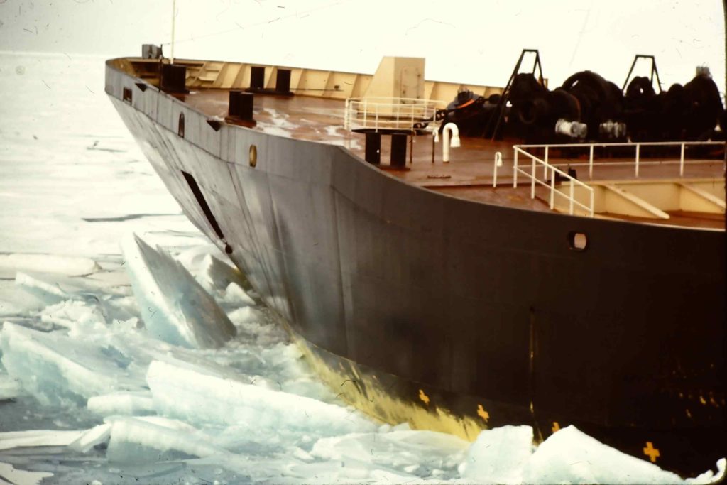
Alongside the Manhattan, the Macdonald charged the ice like an angry bull. As the bow hit the unbroken edge of the pack, it would rise up out of the water, come crashing down and through the ice, and the whole ship would rumble and shake and shudder as it came to an abrupt halt. Then the “Johnny Mac” would roar full power astern, reverse props with another shudder, and come charging full speed again at the ice.
The massive Manhattan, which takes a good many miles to gain full speed, could never lift its 54-foot hull on top of the ice. Against the ice the bow rose only slightly, gently. Nor did it rumble, nor shake, nor shudder. There were muffled bangs, like the sound of empty barrels hit with soft rubber hammers, as the ice clanged against the bow, and the ship cut through, gliding sedately forward as if nothing in the world could ever stop its awesome momentum. But when the ice got thicker and stronger and pressure greater, its speed became very gradually slower. It didn’t seem to really stop; it was just that after awhile it was no longer moving. Motionless for a few minutes, it would then inch astern, imperceptibly at first, preparing for another run at the ice.
But sometimes it was not able to move astern, and that is when the Johnny Mac would come crashing alongside, breaking the ice and relieving the pressure which held the Manhattan fast.
The polar floe that held the Manhattan off Mercy Bay was a pan of ice, several miles across, thicker and stronger than most of the other ice that clogged McLure Strait. When it was flat, it was 10 feet thick, and in the pressure ridges, it was twice as thick. It was crystal blue ice, clear, sparkling, drained of its salt, seemingly as strong as concrete. In front of the bow, the impact of 151,000 tons caused the ice to buckle and fold in accordion pleats. Farther back, against the shoulders of the bow, massive hunks of ice were pushed down into the water, then swooshed up like whales at play.
Captain Steward, who had never broken though ice with a ship before, was learning the intricate techniques, with the advice of experienced Canadians. Ramming back and forth he dubbed the “yo-yo system,” declaring that “you just gotta keep a swinging.”
Thanks to the assistance of the Macdonald, the Manhattan kept swinging until it eventually broke through the polar ice floe, made a big U-turn, and, skirting around the floe this time, headed out of McLure Strait to take the easier way through the passage down Prince of Wales Strait.
But heading into the entrance of Prince of Wales, there were more problems. Here the ice pack, where it was flat, was only about six feet thick and easily handled by the Manhattan— except for row after row of pressure ridges, with more than 20 feet of ice. “The hedge rows of the Arctic landscape,” is how they were described in McLure’s journal. Thrust up by the pressure of sheets of ice pressing against each other, the pressure ridges were marked by jumbled blocks of ice, as large as automobiles, stretching for miles in straight, parallel rows. “It’s like sailing through a rock quarry,” commented Captain Fournier on the Macdonald, as he struggled for 2-1/2 hours to bash his ship through one ridge.
For the Macdonald, following the track of the Manhattan across this stretch was even tougher than breaking its own track. But in this area, once astern there was no way that the Macdonald could escape from the track of the big tanker. Plowing through the ice, the Manhattan cut a 150-foot swath. But all the ice it broke was left behind in its track. If, under pressure, the pack quickly closes to a narrow track of, say, 50 feet, then the broken off chunks of ice become piled up and the ice is thus thicker than it was. It was all the Macdonald could do to follow the icebreaker tanker.
The Manhattan had its problems, too. Before the stern had passed free of one pressure ridge, the bow, a thousand feet ahead, was already plowing into the next pressure ridge. To tackle the pressure ridges blocking the entrance to Prince of Wales Strait, the Manhattan stopped for adjustments. A relief valve, which was leaking steam, was repaired. Steam normally piped to the deck to operate winches and cranes, and steam used for the ship’s desalination plant to provide fresh water, was temporarily diverted to increase the horsepower available to the twin propellers by nearly five percent. The extra 2,000 horsepower thus gained resulted in the Manhattan’s best performance on its western crossing of the Northwest Passage, enabling it to slice slowly but steadily through ice as thick and tough as that which before had stopped it.
Out of the Northwest Passage, in open water 10 miles off Sachs Harbour, at the southwest tip of Banks Island, the two ships hove to on September 15. Helicopters lifted the Macdonald’s press crew to Inuvik and flights home. The Northwest Passage had been licked. The rest of the distance from Sachs Harbour to Prudhoe Bay was open water. If there was difficulty on the return journey, assistance was available from the powerful St. Laurent, standing by at Resolute.
Aboard the Macdonald, Captain Fournier paid tribute to the Manhattan:
“We have all learned a lot from that icebreaker tanker. We learn every day up here. I really was impressed by the Manhattan’s performance and the way she cut through the polar pack. I think they could have done it by themselves, but it would have taken much longer. When they were stuck, they may have had to wait until the ice conditions changed, and that could have been a day or a week, each time.”
And Hass had a final summation to make:
“We have seen nothing which indicates that it will not be possible to operate commercial shipping through the Northwest Passage. Our objective is still commercial shipping on a year-round basis.”
POSTSCRIPT
It has taken four decades, but regular cargo and passenger shipping through the NWP seems in sight, and a busy reality for a six- to-eight-week August and September period, as I write this in late 2016.
The Manhattan made a second NWP voyage in 1970, before Humble and its Prudhoe Bay partners opted for an 800-mile trans-Alaska pipeline to move their oil to a Pacific coast harbour, rather than tanker shipping through the Arctic ocean.
Thirty-seven years after the Manhattan’s first polar voyage, the Chinese seemed every bit as buoyant as Humble had been. “There will be Chinese flags sailing through” the Northwest Passage, Liu Pendfei, a spokesman for China’s Maritime Safety Administration told the Toronto Globe and Mail, April 20, 2016. “Once this route is commonly used it will directly change global marine transportation and have a profound influence on international trade, the world economy, capital flow, and resource exploitation.” To prepare for that pending day the Chinese government published a 365-page Chinese-language Arctic Navigation Guide (Northwest Passage) filled with “charts and detailed information on sea ice and weather.”
More than 100 vessels passed through the NWP in the decade leading to 2017 during the short summer sailing season. The smallest appears to be an 18-foot open Boston Whaler. The most unique was a 25-foot catamaran that sailed over water and slid over ice, the first to make the crossing without an engine, during two summers. The largest was the Chinese-owned cruise ship Crystal Serenity. Towering 13 storeys high and 820 feet long, she left Seward, Alaska on August 16, 2016, carrying 1,700 passengers and crew for a 32-day cruise to New York City.
In September 2013, the ice-strengthened Danish bulk carrier MV Nordic Orion made the first complete crossing of the Northwest Passage by a cargo ship, accompanied by a Canadian Coastguard breaker. She carried 15,000 metric tons of coking coal from Vancouver to the Finnish port of Pori on a route that was 1,000 miles shorter than via the Panama Canal, saving four days of shipping time and $200,000 fuel costs.
Even more impressive in 2014 was the first unescorted crossing of the NWP by a commercial ship, cutting the distance from Deception Bay at the tip of northern Quebec to Bayuquan, China by 5,000 miles, the sailing time by 18 days, and the emission of greenhouse gases by 1,300 tonnes. The M.V. Nunavik, described by the Fednav Group as “the most powerful ice-breaking bulk carrier in the world,” carried 13,000 tons of nickel ore from the Nunavik mine in northern Quebec, to the Chinese port. Where the Nordic Orion and other vessels skirted south of three of the islands in the NWP, the Nunavik took the same more northerly, wider and deep route as the Manhattan: up Davis Strait and Baffin Bay, through Lancaster Sound, down the Prince of Wales Strait between Banks and Victoria Islands. Where the Manhattan struggled in difficult ice 35 years earlier, the Nunavik encountered no significant ice challenges.
Big shippers: miners and oilers
Before the current summer flotillas of small boat and big ships, pleasure and cargo vessels, before the Manhattan voyage, mining and oil companies were shipping through sections of the NWP, bringing in thousands of tons of equipment and material, flying in thousands workers and supplies, and shipping out greater quantities of ore. The first was the short lived North Rankin Nickel Mine on Rankin Inlet, Nunavut, which shipped ore from 1957 to 1962 at a time of peak nickel prices. The town established at the mine housed 500 people when the mine came. The Nanisivik lead and zinc mine at the northern end of Baffin Island, shipped ore during the summer seasons from 1976 to 2002, trucking the ore 1.5 miles from the mine to Nanisivik harbor.
The Polaris lead and zinc mine on Little Cornwallis Island, about a third of the way into the NWP from the eastern Lancaster Sound entrance, shipped out 21 million tons of ore with a market value of $15 billion from 1981-2002. The ice-breaker MV Arctic carried the ore through the eastern third of the NWP for 22 years.
Not far from the abandoned Nanisivik mine on Baffin Island, Baffinland—owned 50-50 by ArcelorMittal, the world’s largest steel produce, and a private investment firm—began shipping ore in 2015 from its Mary River mine, one of the world’s richest iron ore deposits.
Oil companies shipped and flew into the NWP the most equipment, spent the most money, found large accumulations of oil and gas, but shipped out only a token barrels of oil. Following geological and seismic work, the first Arctic Islands well was drilled on Melville to 13,000 feet in 1961, a dry hole. The Panarctic consortium of oil companies spent nearly a billion dollars, to drill 120 wildcat and 40 development wells on and offshore from the Arctic Islands in an area twice the size of Texas from 1967 to 1987. Drilling rigs and equipment were brought in by cargo ships and tug and barge to the principal staging area, the Resolute harbour on Cornwallis Island. Panarctic found oil and gas that would have a market value of $100 billion at 2016 prices, if it could be produced and transported at a cost less than the price.
The first wildcat in the Mackenzie River Delta was drilled in 1965. Ten years later drilling was extended into the adjacent Beaufort Sea, site of the greatest armada of NWP vessels. At its peak in 1985, wildcats had been drilled from 19 artificial islands dredged from the bottom of the Beaufort Sea. There were also six ice-reinforced drill ships; a number of innovative steel (or steel and concrete) drilling platforms, some portable; 14 icebreaker supply ships; a floating dry dock, and a supertanker with a supply of 650,000 of fuel oil.
The technically, if not economically, producible oil and gas discovered to date on and offshore from the Arctic Islands and the Mackenzie Delta-Beaufort Sea area, are estimated at some five billions barrels of oil and equivalent natural gas (referred to by the industry as “boe”). That compares to less than two billion barrels of oil in Canada’s largest conventional oilfield, the Pembina field in Alberta. The undiscovered petroleum accumulations in this Arctic region are vastly greater, but in 2016, no one was searching for them.
What Canada needs to assert control
As the polar ice recedes under the glare of global warming, other NWP issues emerge—political and safety issues.
Michael Byers, Canada Research Chair in Global Politics and International Law at the University of British Columbia, writes in the Globe and Mail, August 12, 2016:
Designated shipping lanes are needed to prevent collisions and to route ships around environmentally sensitive areas. Speed limits are needed to reduce the effects of wakes on shore habitats and noise on marine animals. A ban on the use of heavy fuel is needed to reduce the “black carbon” that lands on snow and ice and accelerates its melting, along with a ban on the emptying of ballasts tanks to reduce the risk of introducing invasive species. Canada has these protections in the St. Lawrence Seaway; now, it needs them in the Arctic.”
In essence, Canada will need deep sea ports, search and rescue staging area, patrol vessels, and more icebreakers.
The need was dramatically illustrated in February, 2016, when the 220-foot Canadian trawler Saputi hit an ice in Davis Strait, near Iqaluit and the southern end of Baffin Island, and began taking on water faster than her pumps could bailing it out. The nearest Canadian help was 1,300 miles away, at the Canadian Coast Guard base in Dartmouth, Nova Scotia, and the Canadian Forces Joint Rescue Centre in nearby Halifax. The Coastguard sent a helicopter, presumably to rescue the sailors. The Rescue Centre airlifted a bilge pump. But it was the Danish Navy patrol vessel HDMS Knud Rasmussen that rescued the Canadian vessel, escorting her 500 miles to Nuuk, Greenland, with Saputi bailing water all the way.
There are no staging areas nor deep sea ports ins the Canadian Arctic to serve shipping, aside from one privately-owned port to serve its own needs, Baffinland’s port at the northern end of Baffin Island, used for summer shipments of iron ore from the nearby Mary River mine. The Canadian Coast Guard has six Arctic icebreakers. Two of them are rated as “Arctic class 4” icebreakers, more powerful and capable than the retired John A Macdonald. The four other icebreakers are rated Arctic Class, and can “navigate at three knots in ice that is one metre thick,” the Coastguard states. They can handle ice at least as well as the Macdonald could.
More is coming. Work is either underway or scheduled for one deep sea port, a refuelling station, six armed Arctic patrol vessels, and Canada’s most powerful icebreaker.
On March 16, 2016, the Nunavut legislature approved construction of an $84 million seaport at Iqaluit, the capital of Nunavut, with a population of some 7,000, and near where the Saputi hit ice a year earlier. Most of the money is to come from the federal government, with completion scheduled for 2020.
At the northern end of Baffin Island, work started in 2015 on a $116 million refueling station in Nanisivik harbour, refurbishing a dock and tank farm used by Nanisivk mines 1972-2003. Scheduled for completion in 2018, it will be used by the Coastguard, the navy’s new patrol vessels, and will be available for use by others. It is a scaled back version of a more extensive deep sea port that was estimated to cost $258 million.
Logical sites for two more NWP deep sea ports and search-and-rescue bases include the harbors at Resolute, on Cornwallis Island, which served much of Panarctic’s operations; Winter Harbour on Melville Island, to where a drilling and tons on equipment were shipped in 1961 for the first well drilled on the Arctic Islands; and at Tuktoyaktuk, a port for vessels used in Beaufort sea drilling.
In Halifax, work construction started in 2015 on the first two of six planned “Arctic Offshore Patrol” vessels for the navy, estimated to cost a combined $3.5 billion. HMCS Harry De Wolf and HMCS Margaret Brooke are both scheduled for launching in 2018.
Work on construction of the $1.3 billion CCGS John G. Diefenbaker was deferred in order to build the patrol vessels first. Now scheduled for launching in 2022, the Diefenbaker will have a planned ability of “unrestricted operations for a nine-month period” throughout the Northwest Passage.
Much more than has been announced will be needed if commercial shipping for more than two months a year is to become a reality within the next decade or two.
Prudhoe Bay and the Arctic’s fading petroleum bonanza
The drift of continents during millions of years once placed the Arctic near the equator. “Tropical plants and ferns,” the raw material of oil and gas, “grew in great profusion,” Standard Oil’s chief geologist Wallace Pratt, noted in 1944. Thus the petroleum potential of the “lands that edge the Polar Sea—the northern shores of Siberia, Alaska, and Canada,” were seen by Pratt to rival the world’s greatest oil regions.
The oil and gas field at Prudhoe is an indication. Its 16 billion barrels of economically recoverable oil is twice as much oil as the East Texas, the next largest oilfield in North America, and about equal to all the recovered and remaining recoverable conventional oil in all the oil fields of Alberta. Its peak daily production rate of 1.6 million barrels of oil in 1987 was as great as all the oil consumption in Canada. By 2016, the production rate had declined to about 300,000 barrels a day, and less than four million barrels remained to be produced.
Prudhoe Bay also has some 35 trillion cubic feet of natural gas, the equivalent energy of about six billion barrels of oil. But while most of Prudhoe Bay’s oil has been consumed, essential none of the gas has. And might never.
Three to four decades ago, a pipeline stretching thousands of miles to move gas from Prudhoe Bay and the Mackenzie River was seen by the U.S. and Canadian governments as an urgent necessity to meet the energy needs and security of the continent. “I will personally insist that this gas pipeline be built without further delay,” president Jimmy Carter promised in a nationally televised address in 1979. “We strongly favour prompt completion” of the Alaskan gas pipeline President Ronald Reagan told a joint session of Canada’s Parliament in 1981.
The unanticipated advent of horizon drilling and hydraulic fracturing released enormous volumes of both gas and oil trapped in shale rocks throughout much of the lower 48 U.S. states and Western Canada, revolutionizing the continent’s energy supplies and eliminating the need for costly distant transportation of gas from the Arctic.
The need to curb global warming catastrophe by slashing the use of fossil fuels adds further pressure to assign Arctic petroleum resources to oblivion. In the 20-year period to 2016, global weather disasters killed 600,000 people; four billion were injured, displaced, or required emergency assistance; and inflicted costs were well in excess of $1.9 trillion (U.S.), the United Nations Office for Disaster Risk Reductions reports in a November 2015 document, The Human Cost of Weather Related Disasters 1995-2015. Scientists can’t calculate how much of this was caused by global warming, but here’s a good clue: the number of global disasters in the 10-year period to 2016 was twice the number in the preceding 10 years, and the storms were more destructive. With the continuing, and now accelerating rise in global temperatures, “we will witness a continued upward trend in weather related disasters in the decades ahead,” the UN agency warns.
First of the major oil companies to announce that it was abandoning its quest for oil and gas off the northern Arctic coasts of Alaska and Canada was Royal Dutch Shell, in 2015, following the abandonment of its most costly hole drilled 70 miles off the northwest coast of Alaska, and expenditures of $7 billion (U.S.) Shell surrendered all its Arctic exploration permits, including some two million acres in Lancaster near the eastern end of the NWP. The surrendered Lancaster permits are expected to be included in a 13 million-acre National Marine Protected Area, in which no oil exploration will be permitted.
“Oil in the Arctic awaits the advance of civilization upon this, the last of our geographical frontiers,” Wallace Pratt wrote in 1994. If the world is fortunate, it will wait forever. If it were needed, the undiscovered petroleum of the Arctic would be worth trillions of dollars, at current market prices. If it would simply add to a surplus storehouse of oil and gas energy, it’s global value would be nil. If finding, producing and using that energy added to global emissions of global-warming greenhouse gases, the cost would be measured in untold trillions of dollars.
Up to Canada to control the Northwest Passage
Still unresolved is whether the NWP is “Canadian internal waters” or an “international strait.” With the United States and the European Union opposed, only Russia and other Arctic nations have supported Canada’s claim, asserting the same claim of ownership off its northern Arctic coast.
Less than a year after the Manhattan’s first NWP transit, the Trudeau government enacted the 1970 Arctic Waters Pollution Prevention Act, asserting jurisdiction for environmental purposes on all ships within 100 nautical miles of Canada’s Arctic Coast. The United States opposed the legislation, but the Act was effectively confirmed by the United Nations in its 1982 Convention of the Law of the Sea.
A ruckus arose in 1985 when the U.S. Coast Guard icebreaker Polar Sea sailed through the Passage from Greenland to Alaska. The U.S. notified Canada in advance, and Canada provided observers aboard the Polar Sea, but Canada’s permission was not requested. The Polar Sea created a storm of controversy in Parliament and the news media. The incident was resolved by a Canada-U.S. Agreement on Arctic Cooperation, signed January 11, 1988, in which the United States “pledges that all navigation by U.S. icebreakers within waters claimed by Canada will be undertaken with the consent of the Government of Canada.” The agreement conforms with the UN’s Law of the Sea, under which any research work in the NWP does require Canadian permission. When U.S. Coastguard vessels enter Canada’s section of the NWP, they are now essentially considered research vessels.
Whatever the legal status, the United States could benefit from Canadian control of the NWP for more than just environmental purposes. No other nation can both patrol the Canadian section of the NWP to guard against smuggling, illegal immigration, or the infiltration of terrorists and terrorist activities, and also establish needed deep sea ports and search and rescue facilities. The onus is on Canada to assert control of shipping through the Northwest Passage, with patrol vessels, world-class icebreakers, deep sea ports, and search-and-rescue facilities.
Unfamiliar Canadian History Stories 1276)